|
|
 |
 |
 |
 |
|
Garmin
eTrex Vista GPS receiver Review |
24th January
2003 |
|
|
Reviewed by
Dave Burrows
|
 |
| What
do you get?
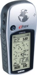
The
Garmin eTrex Vista receiver is priced at around £279.99 including
VAT
and comes complete with a quick reference guide, a full manual, and
an interface cable to a PC.
The
Garmin comes with a base map but has been designed to work with
a number of additional downloadable maps. The one we tested was
the Europe MetroGuide which comes on a double CD and provides management
software and map data for the Garmin courtesy of NavTech Maps.
Garmin Europe MetroGuide is priced at Ł99.99 from
GPS
Warehouse
The
cable set used connecting the Vista to the Pocket PC was provided by
PC-Mobile
and comes in a number of modular
pluggable
cables which can be set into a number of configurations or you can
by a new adapter for another Pocket PC without having to by a complete
lead set. |
 |
|
Garmin
eTrex Vista Specification
The
manufacturer's specification are quoted here.
Navigation
Features
-
Waypoints/Icons: 500 with name and graphic symbol
- Tracks:
Automatic track log; 10 saved tracks let you retrace your path in both
directions
- Routes:
20 reversible routes with up to 50 waypoints
- Trip
computer: Current speed, average speed, time of
sunrise/sunset, resetable maximum speed, trip timer, and trip distance
- Map datums:
More than 100
- Position
format: Lat/Lon, UTM/UPS, Maidenhead, MGRS, Loran TDs, and
other grids
Electronic compass features
-
Accuracy: ±2 degrees with
proper calibration (typical); ±5 degrees in extreme northern and
southern latitudes
-
Resolution: 1 degree
Barometric altimeter features
-
Accuracy: 10 feet with proper
calibration (user and/or automatic calibration)
-
Resolution: 1 foot
-
Range: -2,000 to 30,000 feet
-
Elevation
computer: Current elevation, resetable minimum and maximum
elevation, ascent/descent rate, total ascent/descent, average and
maximum ascent/descent rate
-
Pressure: Local pressure
(mbar/inches HG), 12-hour automatic pressure trend recording
GPS Performance
-
Receiver: WAAS-enabled,
differential-ready, 12 parallel channel GPS receiver continuously
tracks and uses up to 12 satellites to compute and update your
position
Acquisition Times:
- Warm: approx. 15 seconds
- Cold: approx. 45 seconds
- AutoLocate™: approx. 5 sminutes
- Update Rate: 1 second, continuous
GPS Accuracy:
- Position: <15 meters, 95% typical*
- Velocity: 0.05 meter/sec steady state
DGPS Accuracy:
- Position: 3-5 meters, 95% typical*
- Velocity: 0.05 meter/sec steady state
WAAS Accuracy:
- Position: <3 meters, 95% typical*
- Velocity: 0.05 meter/sec steady state
Dynamics: 6g's
Interfaces: RS232 with NMEA 0183, RTCM 104 DGPS data format and
proprietary GARMIN
Antenna: Built-in patch
Physical
- Size:
4.4"H x 2.0"W x 1.2"D (11.2 x 5.1 x 3.0 cm)
- Weight: 5.3 ounces (150 g) with batteries
- Display: 2.1"H x 1.1"W (5.4 x 2.7 cm) high-contrast LCD with
bright backlighting
- Case: Waterproof to IEC 529 IPX7 standards
- Temperature range: 5°F to 158°F (-15°C to 70°C)
- Data storage: Indefinite; no memory battery required
- Internal Memory: 24 MB
Power
- Source: 2 AA batteries (not included)
- Battery Life: Up to 12 hours (typical use) |
|
The Garmin
eTrex Vista Receiver |
|
 |
The
first thing you notice when you take the Vista out of the box is
just how tiny it really is. It's about the size of a regular
Nokia mobile phone in height and it's very light weight! The
battery compartment is situated on the back and comprises of 2xAA
batteries. Although you could put rechargeable NiCad or NiMh
batteries in there, the Vista tends to prefer alkaline, and bear in
mind that rechargeable batteries supply 2.4 volts as opposed to 3
volts.
Like a lot of the Garmin range, the
Vista has a rugged waterproof case and it shows with rubber seals to
keep water out of every nook and cranny.
The Vista sits nicely in the palm of
your hand, and is designed so that you can operate all the buttons
single handed so you can keep your other hand free, and this works
well.
|
 |
|
The display is a four level gray LCD screen with backlight. It has a high resolution
screen of 288 by
160 pixels which is higher than the Garmin GPSMap76, however the
screen is much smaller and allows you to get as much as you would
see on a GPSMap76 onto the smaller Vista screen.
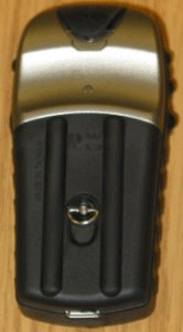
On the back of the receiver there is the quarter turn battery
locking mechanism hiding the two AA sized batteries.
Also on the back located
behind a rubber gasket is the Garmin proprietary interface connector. It is this connector that allows the Garmin to be interfaced to
either a PC or more importantly your PDA.
|
|
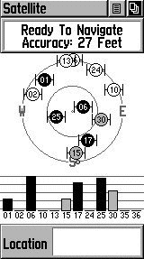
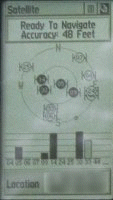
GPS
Satellite Fixing
After
experiencing the strength of the Garmin GPSMap76, and being spoilt
for choice, we were kind of expecting the same excellence in signal
strength. One thing to note is that the antenna's on the Vista
and GPSMap76 are different, the GPSMap76 sports a quad helix antenna
where as the eTrex range does not. This does show, and
performance isn't as great as Garmin's using the quad helix, but
still the performance is more than acceptable compared to most GPS
receivers.
The
Vista in our tests seems to receive more signal when horizontal or
at a 45 degree angle, where as Garmin's with the quad helix tend to
see more signal strength when held vertical, which is corroborated
from views of other GPS users.
The
Satellite screen shows up to 12 satellites it knows are in the sky,
and shows which ones have complete ephemeris data for and which
one's its currently getting this from, to the right you'll see a 4
satellite 3D fix.
The
average fix I seemed to receive was around the 50 second mark,
although I did have some longer fixes of around the 2 minute mark
when it failed to download a complete set of ephemeris data in the
allotted time period.
|
 |
|
One
thing I do like on the Garmin's, is leave them for a few minutes and
they'll bleep at you and come back telling you they couldn't receive
a full fix, would you like to continue ? or initiate a cold/factory fix
?,
which I really do think should be something that should be added
into most Pocket PC GPS Receivers, or at least the applications.
This would help diagnose TTFF problems and help people see there's a
problem quicker rather than dumbly sit there waiting for a fix.
Holding
a fix is just as important as getting the first fix, and the Vista
was certainly able to do that, however compared to the GPSMap76, we
did notice the signal bar's jumping around quite a bit whilst using
the Vista for in-car use. I think this would have been where
the quad helix antenna would come in better, but adding support for
this inside the Vista would increase it's size substantially.
|
|
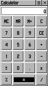
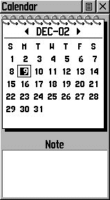
Two applications you don't usually see on a Garmin
are a Calculator and a Calendar. This strangely enough does
come in quite handy, as you're always left wanting these functions,
and although these are being added into most mobile phones now a
days, it's still a welcome edition to a GPS receiver providing that
it doesn't limit the receiver in any ways to the normal GPS functions.
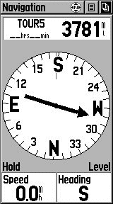
A further welcome edition not seen in many of the
lower spec Garmin's is a compass that not only works as a compass
should, but to be able to tell you what direction to travel towards
for your next waypoint. This is a very neat feature, and is
not tied to GPS signal, so you can quite happily use this if the
Global Positioning System signals were blocked or not available for
whatever reason.
|
|
 |
|
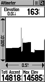
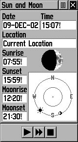
Something
you see on most Garmin's now a days is the barometric altimeter that gives you
the distance and maximum elevation plotted to a graph, the Sun's
sunrise and sunset, and the moon's moonrise and moonset. These
are all essential to the hiker, and if you're out in the wilderness
you also can receive hunting and fishing times which are approximate
timings where you might expect to catch more fish, this does also
depend on weather and location, so the prediction given is just
that, a prediction, and shouldn't be necessarily deemed accurate.
|
|
 |
|
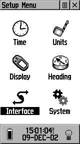
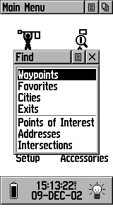
Vista
Setup Menus
The menu's
on the Vista are operated using the click stick on the front of the
receiver. It's good to
see everything is accessible quickly without having to wade through
countless menus.
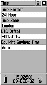
On the
main setup menu you have everything you need here from setting the
time formats from 12 to 24 hours, the time zone you're currently
located in, any UTC offset and whether you are currently in Daylight
Savings Time.
The date
and time will be set when you acquire your first fix, and on future
fixes as this is synchronised as part of the NMEA sentence received.
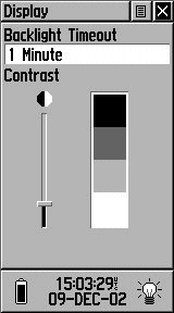
One thing
that is important on gray scale screens is a contrast control,
depending on whether you're in shade, or in the open bright sun, you
may need to tweak contrast and the Vista
like other Garmin's has a 4 level gray scale control with a backlight facility that you can set to a timeout of 15 seconds
up to 2 minutes in length before the backlight will turn itself off.
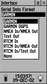
As in
previous Garmin's, Garmin offer a rich serial data format comprising
of Garmin's own proprietary format, Garmin DGPS for Differential or
WAAS data, NMEA In/NMEA Out which is the standard that most people
would use when connecting to a PC or Pocket PC, Text Out, RTCM In,
RTCM In/NMEA Out, RTCM In/Text Out. This gives
users of the Vista a vast amount of export options allowing for both WAAS and NMEA data transfer.
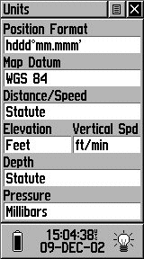
You can also change the units
that are displayed on the Vista in the Position Format and Garmin
offer a large selection of Map Datum Support for nearly all Map
Datum's in existence. WGS 84 is the default selection which
corresponds to World Geodetic Survey 1984 and is the most commonly
used.
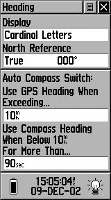
As Garmin
have included full magnetic compass support in the Vista, you have a
function to automatically switch off the compass over a particular
speed. This is handy because the Compass does use up a lot
more battery power, and one thing Garmin do stipulate is to not have
the Compass turned on all the time.
|
 |
|
 |
WAAS
what is it? WAAS stands for Wide Area Augmentation System. It's a system of satellites and ground stations that
provide GPS signal corrections, giving you even better position
accuracy. How much better? Try an average of up to five times better.
A WAAS-capable receiver can give you a position accuracy of better
than three meters, 95 percent of the time, and you don't have to
purchase additional receiving equipment or pay service fees to utilize WAAS. You can find out more about WAAS at http://www.garmin.com/aboutGPS/waas.html
OK
so WAAS is good, but it does not come configured as standard. You
need to go into the Setup Menu and enable WAAS as shown on the left.
Once enabled you need to initialise the receiver with a good view
of the sky and you should see your GPS fixes change into Differential
fixes.
How
can you tell if you are getting WAAS fixes? First of all on the
sky page you will see differential fix messages and in the satellite
strength bars a 'D' will appear indicating that the satellite is
being used in the WAAS fix.
Check
out our EGNOS/WAAS
Article for more information of the use of EGNOS in the UK
|
|
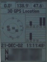
The
sequence and messages displayed are as follows:
- Acquiring
Satellites is displayed when the receiver is first switched
on, or if you have lost your fix for some reason. This means that
the unit is attempting to get a fix.
- 2D
GPS Location is
shown when the GPS receiver has a fix on 3 satellites. When you
get a 2D fix the receiver can display your position but not your
altitude.
- 3D
GPS Location
is displayed when there is a fix on 4 or more satellites. In this
mode the GPS unit can display both position and altitude.
- 2D
Differential Location
indicates that the receiver is using either DGPS or WAAS differential
data on 3 satellites
- 3D
Differential Location
shows that the GPS unit is receiving differential data on 4 or
more satellites. This is the most accurate fix you get with this
receiver.
|
|
Connecting the Vista to a
Pocket PC
This can be done very easily with a cable set supplied from
PC-Mobile.
All you need to do is set the Garmin Vista interface to NMEA
In/NMEA Out, and connect it up to your Pocket PC and use any GPS
package set to COM1 and NMEA 4800 and you should start receiving
the NMEA data stream.
This can be verified by using
WinFast Navigator which is available on our downloads page, or
G7To CE which is also available from our downloads page.
|
|
Connecting the Vista to a PC
I loaded the Map Source
MetroGuide software onto my laptop and connected up the Garmin
Vista with the supplied cable that comes in the box. This
enabled me to download further maps to the Vista allowing for
greater use out of the Vista. The maps were
spot on and located me on the map exactly where I was. The roads are sources
from the NavTech database.
The Garmin has sets
of displays named pages. These are the Satellite Page, the Map Page,
the Compass page, the Highway page, the Route page.
|
|
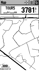 |
The
map page shows the available map data, superimposed with your route,
waypoints, tracks etc.
You can choose various levels of zoom
by using the Zoom in and Zoom out buttons on the left hand side of
the Vista.
By pressing the menu
button you can set up the fields displayed on the screen, and other
options for the map display.
In general this applies
to all pages. Pressing the menu button displays context sensitive
options for the page as shown on the right. Pressing the menu button
again will display the main setup menu.
|
 |
|
Comparing the Vista to the GPSMap76
The Vista does hold up well when
compared to the GPSMap76 when stationary. You'll see very
comparative signal strengths when stationary, although if you're
using a Vista in-car, you'll find this is where the GPSMap76S will
excel, but for nearly Ł100 more, you do have to ask yourself for
what really is a larger screen and a quad helix antenna, is it worth
the extra Ł100 ? If size is an issue to you, and you want a
GPS receiver that can easily fit inside your shirt pocket, and you
don't mind the smaller screen albeit with a higher resolution, then
the Vista will probably come out tops and save you a nice packet.
However if you're not really going to
use the Vista for hiking and you're mainly going to use it in-car
coupled with a laptop or PDA, then this is where the GPSMap76 and
GPSMap76S will excel. |
 |
|
The Other
Screens
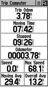
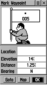
The other screens are displayed here.
Below left you'll see the Trip Computer, below middle the Waypoint
screen and below right the compass screen.
|
|
 |
|
|
|
Strengths
and Weaknesses
The unit tested is one of the top of the range of the consumer handheld GPS systems
available. It's crammed pack full of features, many probably
wouldn't be used, but you have them there if you may need them at any
time. Garmin and others do produce cheaper
units for just over £100 which compare favourably in price
to sleeve and Compact Flash GPS Receivers.
The flexibility of the
system is good, after testing the GPSMap76, I like the Vista, but
the only thing that does let it down is the smaller screen which I
found to be a little too small on numerous occasions.
The biggest plus has to be the feature set and TTFF and the units
ability to retain the fix even in adverse and unsuitable conditions.
Fixing took slightly longer when travelling but you will see this on all GPS receivers.
Purchase from

|
|
|
 |
 |
 |
 |
|
|