|
|
 |
 |
 |
 |
|
Garmin eTrex GPS receiver Review |
04th March 2003 |
|
|
Reviewed by
Mike Barrett
|
 |
| What
do you get?
The
Garmin eTrex receiver is priced at around £114.49 including
VAT
(GPS Warehouse) and comes complete with a quick reference guide, a full manual, and a wrist strap.
You will need a pair of AA sized batteries to run the GPS receiver
which are not included in the package. It is possible to use rechargeable batteries, but normal alkaline batteries are recommended.
To connect the eTrex to a PC you will need a PC Interface cable. The Garmin cable costs about £30.
The
cable set used connecting the eTrex to the Pocket PC was provided by
PC-Mobile
and comes in a number of modular
cables which can be set into a number of configurations so you can
by a new adapter for another Pocket PC without having to by a complete
lead set.
The review unit was kindly lent to us by GPS Warehouse. This was used in conjunction with Garmin eTrail and the PC and PDA applications Autoroute, Fugawi, Memory-Map, OziExplorer, Tom Tom Navigator.
|
 |
|
Garmin
eTrex Specification
The
manufacturer's specification are quoted here.
Navigation
Features
-
Waypoints/Icons: 500 with name and graphic symbol
- Tracks:
Automatic track log; 10 saved tracks let you retrace your path in both
directions
- Routes:
1 reversible route with up to 50 waypoints
- Trip
computer: Current speed, average speed, time of
sunrise/sunset, resetable maximum speed, trip timer, and trip distance
- Map datums:
More than 100
- Position
format: Lat/Lon, UTM/UPS, Maidenhead, MGRS, Loran TDs, and
other grids
GPS Performance
-
Receiver:
differential-ready, 12 parallel channel GPS receiver continuously
tracks and uses up to 12 satellites to compute and update your
position
Acquisition Times:
- Warm: approx. 15 seconds
- Cold: approx. 45 seconds
- AutoLocate™: approx. 5 minutes
- Update Rate: 1 second, continuous
GPS Accuracy:
- Position: <15 meters, (49 feet) RMS
- Velocity: 0.1 knot RMS steady state
Dynamics: 6g's
Interfaces: RS232 with NMEA 0183, RTCM 104 DGPS data format and
proprietary GARMIN
Antenna: Built-in patch
Physical
- Size: 4.4"H x 2.0"W x 1.2"D (11.2 x 5.1 x 3.0 cm)
- Weight: 5.3 ounces (150 g) with batteries
- Display: 2.1"H x 1.1"W (5.4 x 2.7 cm) high-contrast LCD with
bright backlighting
- Case: Waterproof to IEC 529 IPX7 standards
- Temperature range: 5°F to 158°F (-15°C to 70°C)
- Data storage: Indefinite; no memory battery required
Power
- Source: 2 AA batteries (not included)
- Battery Life: Up to 22 hours |
|
The Garmin
eTrex Receiver |
|
|
Dave reviewed the Garmin eTrex Vista receiver a month ago. The Vista is the top model of the eTrex range. I was interested in seeing if the bottom of the range was capable of replacing a GPS sleeve for the PDA and still provide a versatile multifunction capability.
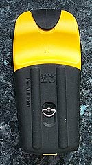
All the eTrex models are the same size and the cases are very similar, varying only in the colour. They are really small, about the size of your palm.
There is a lot of black rubber on the receiver. Not only does this make it waterproof, and float it also makes it stick to the dashboard on your car.
The display is a four level gray LCD screen with backlight. It has a resolution screen of 128 by 64 pixels which is less than both the eTrex Vista and the Garmin GPSMap76, however as the GPS receiver does not support the display of maps it is not an issue.
|
|
|
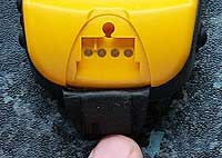 The black tongue at the top on the back protects the electrical communications connectors. This is where the interface cable is plugged in. The four connectors are for data in, data out, ground and power. Both the Garmin PC Interface and the PC-Mobile modular PDA cables fit in this socket. The black tongue at the top on the back protects the electrical communications connectors. This is where the interface cable is plugged in. The four connectors are for data in, data out, ground and power. Both the Garmin PC Interface and the PC-Mobile modular PDA cables fit in this socket.
The specifications above state that the receiver is differential-ready. DGPS can only be achieved with the addition of an external beacon receiver. DGPS (in the form of WAAS or EGNOS) is not built into this device.
The battery compartment is situated on the back and comprises of 2xAA batteries. Although you could put rechargeable NiCad or NiMh batteries in there, the eTrex tends to prefer alkaline batteries. The Garmin specification for minimum voltage is 2.5 volts, rechargeable batteries supply 2.4 volts as opposed to 3 volts supplied by alkaline ones.
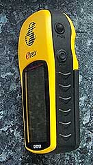 On the right hand side of the eTrex are two buttons. The lower one is the power button which also doubles up as the backlight button. The top button is used to page through the various screens on the receiver. On the right hand side of the eTrex are two buttons. The lower one is the power button which also doubles up as the backlight button. The top button is used to page through the various screens on the receiver.
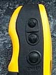 The left hand side of the eTrex contains the remainder of the controlling buttons. The top two move the cursor or selection up and down, whilst the lower button is the enter button. The left hand side of the eTrex contains the remainder of the controlling buttons. The top two move the cursor or selection up and down, whilst the lower button is the enter button.
The operation of these buttons has been designed for single handed operation. Having said that I am left handed and found it much easier to work using both hands. That said I let a few right hookers use it and they had no problems.
Overall the GPS receiver felt well constructed. All the moveable components fitted correctly and felt right in my hand. The device is marginally longer than the palm of my hand and about half the width. The weight felt about right to. About the same as my Nokia 6310i phone. Not light weight and plastic, but solid and not too heavy. |
|
GPS
Satellite Fixing
I think I have been spoilt with my experiences of using GPS receivers. I started with the NavMan sleeve, but my second receiver was the Garmin GPSMap76, closely followed by the Emtac BT GPS both of which are excellent GPS receivers, and was expecting the same sort of abilities from the eTrex. Unfortunately that was not the case, not that the eTrex was bad but it did not fix either as quickly or hold it's fix as well as the other two units. After being turned off for a few days the eTrex still managed to get a fix in 39 seconds.
Interestingly my experiences with TTFF seem to be somewhat better then Dave's which is strange as they both use the same hardware. I did find that the receiver did fix faster if held horizontally rather than vertically, which is the natural way to hold it.
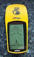
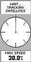
There are two different displays available for the tracking display: a graphical image and a traditional sky view. Shown below are the four screens associated with the GPS satellite fixing. The first one is the "normal skyview" this shows graphically four satellites in the sky, when a satellite is being tracked but has not been fixed yet a dashed line flickers between the person and the satellite. When it is fixed a solid line is displayed as shown below. When 3 satellites have been fixed positional data will be available with a 2D fix, when all 4 are connected then you will have a 3D fix.
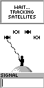 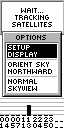  
The
screen can be changed by pressing the lower left (enter) button. This displays a menu which allows you to select from the various options by using the upper two left hand buttons to highlight your selection, then pressing enter again to confirm the selection.
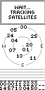
The traditional satellite screen shows up to 12 satellites that it knows are in the sky,
and identifies which ones have complete ephemeris data for and which
one's its currently getting this from.
 The eTrex's ability to hold a fix once obtained was quite reasonable. Again not up to the standard of the Garmin GPSMap76 or Emtac BTGPS, but far better than any of the iPaq GPS sleeves that I have used. The eTrex's ability to hold a fix once obtained was quite reasonable. Again not up to the standard of the Garmin GPSMap76 or Emtac BTGPS, but far better than any of the iPaq GPS sleeves that I have used.
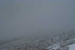
Having said that I was up in the Lake District in Cumbria a couple of weeks ago. We had some horrible weather as can be seen in the photo on the left. During this walk the Garmin eTrex lost it's fix a few times whereas the Emtac BT GPS did not.
Both receivers were in a backpack, with the Emtac actually inside a waterproof otterbox, so both had exactly the same environmental influences. |
Map Displays
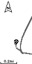 Map display is not really the correct term for this display but this is the one that shows your track and route in a graphical screen. What you actually see on this display is your current position and where you have been. If there are any waypoints or the route encompassed in the current display area then these will be shown as well. Map display is not really the correct term for this display but this is the one that shows your track and route in a graphical screen. What you actually see on this display is your current position and where you have been. If there are any waypoints or the route encompassed in the current display area then these will be shown as well.
The picture on the right shows the track and a "?". The question mark is displayed flashing when there is no GPS fix. Otherwise a small man is shown. When you are moving the man will walk leaving the tracked marked behind. The scale of the display can be modified by pressing the upper left buttons. This scale goes from 200 feet all the way to 800 miles.
The map display can be configured in a number of ways. Pressing the enter button displays the menu shown to the left. From here you can configure the display to: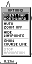
- be North up or course up,
- you can have autozoom enabled to show your entire route automatically,
- you can show or hide the waypoints on the display,
- you can show the bearing line or course line of travel,
- and if you are currently navigating you can stop navigating on the route
|
|
The Pointer Page
  The
various displays on the eTrex are referred to as pages. The pointer
page has three functional areas: Navigation section; Compass and
direction data; and Information area. The
various displays on the eTrex are referred to as pages. The pointer
page has three functional areas: Navigation section; Compass and
direction data; and Information area.
When navigating along a route the
next waypoint in the route is displayed along with distance and
estimated time of arrival. Underneath this will be the pointer.
When the pointer is pointing straight up you are heading in the
correct direction.
At the bottom of the display is the
information panel. This can display 11 types of data including your
position in a number of different formats, your speed, average speed,
trip time etc. The different data types can be changed by using
the upper left scrolling buttons.
Pressing the enter button will show
the pointer options display. From here you can reset trip details
or stop navigating.
|
| eTrex
Menu Page
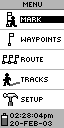 The
menu page is where you control the features of the eTrex receiver.
It has the following functions available: The
menu page is where you control the features of the eTrex receiver.
It has the following functions available:
- Mark - Create a new waypoint
- Manage the list of waypoints
- Manage the route
- Manage tracks
- Set the operational parameters
of the receiver.
|
Mark Waypoint
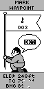 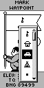 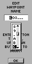 Selecting
the mark waypoint option will display the screen to the far left.
You can change the icon associated with the waypoint and also edit
the name by scrolling the highlight and pressing the enter button. Selecting
the mark waypoint option will display the screen to the far left.
You can change the icon associated with the waypoint and also edit
the name by scrolling the highlight and pressing the enter button.
Changing the icon is not a problem,
just a matter of scrolling down the list of options and pressing
enter. Editing the name is a different matter altogether. For each
letter you need to scroll through the list pressing enter when you
find the right one.
To save the waypoint press enter
when OK is highlighted. |
Manage Waypoints
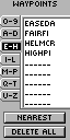
 The
eTrex can store up to 500 waypoints. This can be a nightmare to
manage if you are not careful how they are named. The management
is achieved through selection of the waypoint via the screen shown
on the far left. You can also find the nearest waypoint, or delete
all of the stored waypoints. The
eTrex can store up to 500 waypoints. This can be a nightmare to
manage if you are not careful how they are named. The management
is achieved through selection of the waypoint via the screen shown
on the far left. You can also find the nearest waypoint, or delete
all of the stored waypoints.
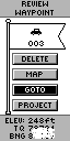
Having selected your waypoint the
review waypoint display is shown. This allows you to navigate to
the waypoint, using GOTO; display the waypoint on the Map Page,
delete the waypoint, or create a new waypoint a specific distance
and bearing from the current position. |
Manage Routes
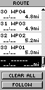 The
eTrex only supports a single route. This can be created or edited
by selecting the location where you want to add a waypoint and then
pressing the enter button. This will then show the waypoint selection
screen as shown above left. The
eTrex only supports a single route. This can be created or edited
by selecting the location where you want to add a waypoint and then
pressing the enter button. This will then show the waypoint selection
screen as shown above left.
When the route is complete you can
navigate along it using the FOLLOW button. This will activate the
route and you will see it highlighted in the other pages already
described. |
Manage Tracks
 The track log screen allows you to manage the tracks in you GPS
receiver. You can have up to 10 tracks stored in the eTrex. The
current track is named the ACTIVELOG. When you select to save the
tracklog you will be prompted to save the entire log, or through
a number of displayed times. Saving the track will not remove it
from the activelog. You will also need to clear the track log.
The track log screen allows you to manage the tracks in you GPS
receiver. You can have up to 10 tracks stored in the eTrex. The
current track is named the ACTIVELOG. When you select to save the
tracklog you will be prompted to save the entire log, or through
a number of displayed times. Saving the track will not remove it
from the activelog. You will also need to clear the track log.
When saving the track a default name
is selected. You will also have the option to rename the tracklog.
The eTrex has a feature known as
TracBack which allows you to retrace your steps by navigating in
reverse along the recorded track. This is activated by selecting
a track, pressing the enter button and then highlighting TRACBAK. |
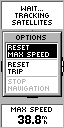
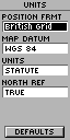
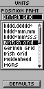
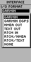
Setup
The final section
of the menu is the setup. This section allows the setting of date
and time options, along with the display settings. The most important
options though are the those shown below: The display and selection
of the units, here you can select a number of options I have selected
British Grid which gives me the position in Ordnance Survey co-ordinates.
The last display is the interface options which define how the eTrex
will communicate with connected equipment.
|
|
Connecting
the eTrex to a Pocket PC
This can be done very easily with a cable set supplied from PC-Mobile.
All you need to do is set the Garmin eTrex interface to NMEA In/NMEA
Out, and connect it up to your Pocket PC and use any GPS package
set to COM1 and NMEA 4800 and you should start receiving the NMEA
data stream.
I
have used this configuration successfully with Tom Tom Navigator,
OziExplorer, Memory-Map and Fugawi
However with applications
like OziExplorerCE and Memory-Map if the interface is set to GARMIN
then the receiver can upload and download information for management
within the PDA. This becomes critical if you want to have a route
with more than 50 waypoints or have more then one route.
|
|
Connecting
the eTrex to a PC
Once
again the Garmin eTrex can be connected to a PC. Why would you want
to connect your GPS to a static PC? Well this is really for 2 reasons:
Firstly the PC does not have to be static, you could be running
on a laptop; secondly using various software packages you can manage
the waypoints, routes, and tracks.
Connecting to a laptop.
I have a 12v converter to power my laptop from the cigarette lighter
in my car. This gives me a fully powered and mobile PC. I have connected
the Garmin eTrex to the laptop and, running Autoroute, plotted out
my current position along the route. This setup worked well, but
the laptop could only realistically be used by a passenger, also
the software is not up to the standard of the PDA GPS navigation
packages.
Connecting to a static
PC I was able to integrate the eTrex with Fugawi, Memory-Map, and
OziExplorer to manage tracks, routes and waypoints. I currently
reviewing Garmin's eTrail software. This connects to the eTrex,
and I can then load the data back into one of my management applications.
This will be described in more detail later.
|
|
Strengths
and Weaknesses
The unit tested is one of the world's popular GPS receivers and
priced at just over £100 compares very favourably in price
to sleeve and Compact Flash GPS Receivers.
Where
the receiver really scores is in the fact that it is a stand-alone
unit which can last up to 22 hours on a set of batteries, far longer
than a PDA. This means that you can use the GPS for extended periods
recording track data, and use a PDA only occasionally when you need to
look at a moving map. You could even take the receiver on an plane
and once electronic gadgets are useable you can record your
flight track, downloading to your PC or PDA when you touch down.
A
big advantage over GPS sleeves and CF receivers is the TTFF and
the receivers ability to retain the fix even in adverse conditions.
It is not as good as the Emtac BTGPS or Garmin GPSMap76 but is about
1/3 the price of those units.
Where I did find it
less than useful was when changing routes due to adverse conditions.
Normally I would build escape routes for a walk which I could switch
to as required. With the capability to store just a single route
switching route requires access to a PDA or computer. Not very
practical on a mountain when you need to make quick and reasoned
decisions. This proves the point of retaining and refreshing traditional
navigational skills. Yes I did have a paper map and compass. The
eTrex was still useful to pinpoint our location as I could read
out the current position in OS co-ordinates.
Purchase from

|
|
|
 |
 |
 |
 |
|
|